|
[ Back ] [ Home ] [ Up ] [ Next ]
[Tikal Trip Recommendations ]
|
Click any picture to
enlarge; then close out of that window to return here.
There are 3 SLIDE SHOWs
so be sure to look at them. |
|
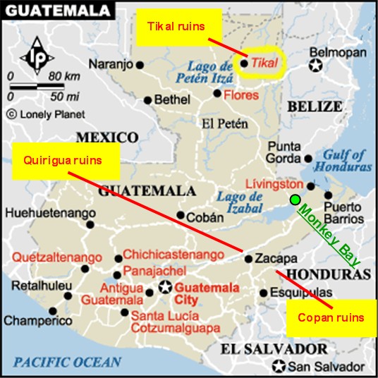
GUATEMALA
Part 3:
Maya Ruins
of Copán, Tikal
and Quiriguá
The Maya culture flourished from 200 BC
to AD 1450. They inhabited the Yucatan Peninsula, Guatemala, Belize,
Honduras and El Salvador -- 324,000 sq. kilometers.
Among their many
achievements, the Maya developed agricultural technology allowing for large
population growth in diverse ecological conditions. They created a
complex writing system, and a vigesimal (based on the number 20) numbering
system which included the concept of "0". They developed a calendar
with remarkable precision. Their political organization consisted of
city/state, and a confederation with a lead chieftain.
But the Maya's
greatest achievement is considered to be architecture, building palaces,
pyramids, temples and causeways. Amazingly, they never knew or used
the wheel, nor utilized beast of burden. Equally staggering is the
absence of metal - Tikal flourished without gold and without metal tools.
Everything they built was with only chipped or ground stone (flint/obsidian)
tools.
The Pre-classic Maya
period dates from 2000 BC - AD 200; Classic period AD 200 - 1000; and the
Post-Classic period AD 1000 - 1450.
|
|
|
|
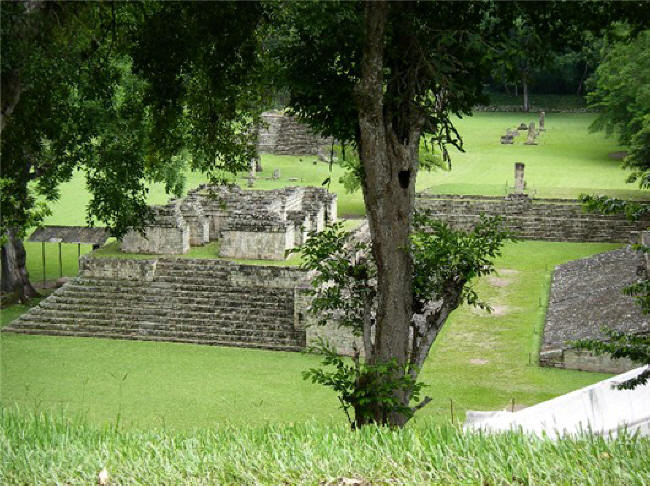
MAYA
RUINS of COPÁN,
HONDURAS 2006
A 4-hour van ride took Deborah and the girls (and a small group of cruisers)
to the Guatemala-Honduras border. We had a very quick and simple
clear-out/clear-in process with both Guatemalan and Honduran customs &
immigrations and paid a $3 fee giving us a 3-day visitors pass good for the Copán
area only. We exchange some Guatemalan quetzals for Honduran lempiras
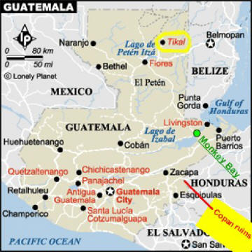
and we're off. A short ride and we're in the town of Copán
Ruinas. The next day
we take off in tuk-tuks for Copán a
mile away where an English-speaking guide has been previously "interviewed"
and retained by our cruiser trip leader. (To see where Copán
is, see above map.)
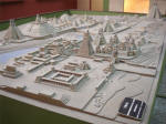
 SIGNIFICANCE: The Tikal ruins in northern Guatemala are better known
than
Copán because of
it's immense size - both in its mega-proportions and number of structures.
Copán, even though not as vast,
is considered superior with respect to its multitude of well-preserved
carvings, sculptures and inscriptions. There have been several
recent, significant finds at this site including the Rosalila Temple in near-perfect
condition and the lengthy Hieroglyphic Stairway. SIGNIFICANCE: The Tikal ruins in northern Guatemala are better known
than
Copán because of
it's immense size - both in its mega-proportions and number of structures.
Copán, even though not as vast,
is considered superior with respect to its multitude of well-preserved
carvings, sculptures and inscriptions. There have been several
recent, significant finds at this site including the Rosalila Temple in near-perfect
condition and the lengthy Hieroglyphic Stairway.
HISTORY: Evidence shows that people had been
living in the
Copán area since
around 1400 BC and that there must have been significant commercial
activity. This dynasty ruled during the Classic period (AD 250 - 900),
with the first noteworthy royal family coming to rule in AD 426, whose
mysterious king, #5, Great Sun Lord Quetzal Macaw, was regarded as a semi-divine
founder of the city. Other rulers included king #12, Smoke Jaguar, who
ruled for a surprising 67 years and was responsible for major military and
commercial endeavors expanding the population; king #13, 18 Rabbit, known for military
conquests although he literally lost his head in a battle with neighboring Quiriguá; king #15, Smoke Shell, who was the greatest builder and was
responsible for the Hieroglyphic Stairway; Yax Pac was king #16. In
all there were 17 rulers. At its peak
around AD 800, Copán had a population of close to 30,000 people - a figure
not again attained until the 1980's.
It has only recently been surmised that the collapse of
Copán was
brought on by a tremendous population growth, straining its agricultural
resources where it was no longer self-sufficient and forcing expansion into
outer areas. What resulted was deforestation, followed by severe
erosion and then flooding, wiping out food sources. Remains have been
found showing that people died of malnutrition and diseases with decreased
life-spans. This is in some ways what is happening in Guatemala now.
Incidentally, a Mayan belief is that life is cyclical and history repeats
itself.
Civilization
didn't die out immediately, though, as it probably existed in some form
until 1200 when nature took over again. In 1576 a Spaniard discovered
the city's ruins, informed the king but no action was taken until almost
300 years later when another Spaniard mapped the area in 1839, making it
known to the world.
Today, 3,450
structures have been found within the immediate area of the
 "Principal
Group", with another 4,500 structures found less than 100 miles away.
There are 5 separate phases, or layers, of construction at
Copán, each
being built on top of the previous. The final phase dated from AD 650
to 820. In many cases the previous structure was destroyed before
building the next - but that wasn't always the case. The layers of buried
ruins underneath the visible ruins are now being explored by means of
underground tunnels, of which 2 are open to the public. The exquisite Rosalila
Temple was discovered this way - intact - and a full size replica is now the
focal point in the onsite
Museum of Sculpture. This museum also houses some of the original pieces
to protect them from the environment; reproductions have replaced the originals
outdoors and are placed in the exact location where they were originally erected. Excavations are continuing and new, exciting discoveries are still being
made. Remember, this IS Central America and these things take time .
. . "Principal
Group", with another 4,500 structures found less than 100 miles away.
There are 5 separate phases, or layers, of construction at
Copán, each
being built on top of the previous. The final phase dated from AD 650
to 820. In many cases the previous structure was destroyed before
building the next - but that wasn't always the case. The layers of buried
ruins underneath the visible ruins are now being explored by means of
underground tunnels, of which 2 are open to the public. The exquisite Rosalila
Temple was discovered this way - intact - and a full size replica is now the
focal point in the onsite
Museum of Sculpture. This museum also houses some of the original pieces
to protect them from the environment; reproductions have replaced the originals
outdoors and are placed in the exact location where they were originally erected. Excavations are continuing and new, exciting discoveries are still being
made. Remember, this IS Central America and these things take time .
. .
We made a
return trip to Copán in January 2008. In addition to the above
ruins, we visited the secondary ruins of Las Sepulturas, the elite
residential area. We also visited Macaw Mountain Bird Reserve, a
pretty forested area where rescued and donated macaws, toucans and parrots
live in the open and where you can hold them. This trip update can
be read at Copán Maya
Ruins '08 on Pictures/Journal page 29.
- -
-
|
COPAN TRIP RECOMMENDATIONS
We made another trip to Copán
in January 2008. We used the same English-speaking ruins park guide I
had in 2006 and would recommend him (although I'm sure any "official" park
guide would be fine): Cesar Aquinp, cell (504)
975-2130, cesarcopan@yahoo.com.
Visiting the secondary ruins of Las Sepulturas is worth it if you have time;
a ruin digger became our unofficial guide and in Spanglish helped us make
sense of the structures and layouts, and not miss some of the great
carvings.
We stayed at Hotel Acropolis Maya and can recommend: tel (504) 651-4634, $40
or $45/night. In 2006, I had stayed at Hotel Plaza Copán,
with pool and more expensive, also nice. We hear that La Casa de
Cafe is very nice but they were full.
A
half-day outing (less than a 10 minute tuk-tuk ride from town) to Macaw
Mountain Bird Reserve is recommended where you can hold a half-dozen macaws,
parrots, toucans, etc. at once (don't forget your camera). Lunch at
their restaurant over the creek is pleasant but the food was ordinary and overpriced for what we
got, and/or sample their good home-grown 'n' processed Miramundo coffee at
their separate cafe.
Recommended restaurants: Carnitas Nia Lola (grilled meats/chicken),
Copán
Pizza, Twisted Tanya, and Xibalba Pub for their "Full Monte" breakfast was
great. We also hear from others that C. Momos and La Casa de Todo are
also good. (Jan. 2008)
|
[ Top of page ]
[ Return to P/J page 29,
Copán ]
|
|

|
|
Read text at left first, then . . . View
SLIDE SHOW
of
Copán Ruins (Honduras) This Slide Show has
great narrative so be sure to click on the first picture to start the
show. |
|
 |
|
|
|
|
|
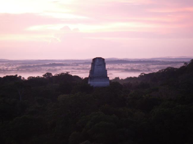
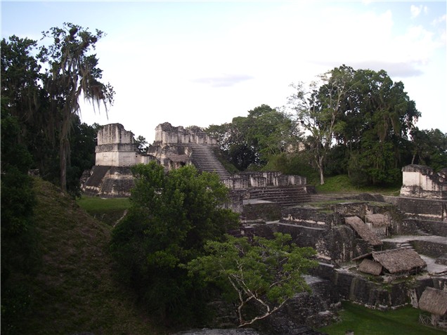
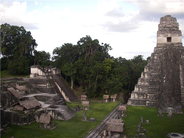
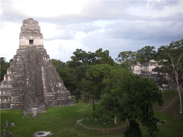
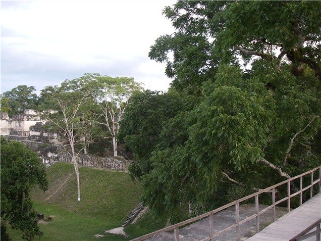
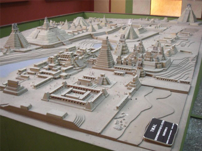
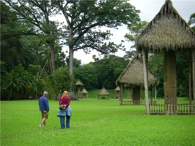
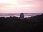
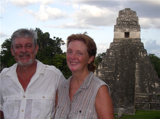
MAYA
RUINS of TIKAL,
GUATEMALA
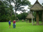
A pleasant 3-hour bus ride from
the Rio Dulce through peaceful countryside puts us on the lake island of Flores
in the northern part of Guatemala. It is an hour ride from there to
Tikal Park.
Based on friends' recommendations,
we spend the first and last nights in Flores;
 then 3 days/ 2 nights in Tikal
Park. This gave us time to explore Tikal without being too rushed or
too exhausted. If you stay on the park grounds as we did, you are able
to be in the ruins area before and after park hours, as long as you have a
guide accompanying you. This not only allowed us to experience Tikal when
tourist are few and wildlife is most active, but also see the full
moon rise, sunrise and sunset from the tops of pyramids with just the eerie
sounds of nature surrounding us in complete darkness, as the ancient
Maya may have done. Simply
magical. then 3 days/ 2 nights in Tikal
Park. This gave us time to explore Tikal without being too rushed or
too exhausted. If you stay on the park grounds as we did, you are able
to be in the ruins area before and after park hours, as long as you have a
guide accompanying you. This not only allowed us to experience Tikal when
tourist are few and wildlife is most active, but also see the full
moon rise, sunrise and sunset from the tops of pyramids with just the eerie
sounds of nature surrounding us in complete darkness, as the ancient
Maya may have done. Simply
magical.
Over our 3 days at Tikal, we walked
many miles each day and climbed at least 7 pyramids. Although it is rainy season we only saw rain late one afternoon for an hour.
SIGNIFICANCE:
Tikal, located deep in the jungle, is known
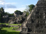 for
its grandeur.
The sheer size
of this ancient Maya city is mind-boggling. Tikal National Park, the
first such park in Central America, covers 222 sq. mi.. Infrared
imaging reveals 10,000 structures. Central Tikal contains 4,000
separate constructions in a 6 sq. mi. area, of which probably half this area
is open to visitors. for
its grandeur.
The sheer size
of this ancient Maya city is mind-boggling. Tikal National Park, the
first such park in Central America, covers 222 sq. mi.. Infrared
imaging reveals 10,000 structures. Central Tikal contains 4,000
separate constructions in a 6 sq. mi. area, of which probably half this area
is open to visitors.
At its peak Tikal had a population of 150,000.
Tikal became the
prime city of the Maya people populating the Yucatan Peninsula.
Evidence indicates that
civilization existed at Tikal from 700 BC to AD 900 when it collapsed for no
apparent reason. It's existence coincides with that of
Copán.
Most of the visible construction at Tikal dates from AD 550 - 900.
HISTORY: The Maya settled this area around 700
BC. Tikal is set on a low hill, possibly to get relief from the
surrounding swampy area. Also, flint is in abundance here, the
principal material from which tools and hunting weapons were made.
Around AD 250 Tikal had become an important religious,
cultural and commercial city with a large population. Under King Yax
Moch Xoc, the dynasty that would rule Tikal thereafter began. In the
mid-4th century, Tikal adopted a new and brutal method of warfare used by the
rulers of Teotihuacán
in Mexico. Instead of engaging in hand-to-hand combat, support units
would surround the enemy and throw spears from a distance to kill them -
the first use of "air power". This enabled Tikal to conquer an adjacent
civilization to become the dominant kingdom in El Petén.
Tikal suffered in the 6th century when it was defeated by another king using
their own warfare methods.
In the late 600's, the very popular King Moon Double
Comb, also called Lord Chocolate, restored Tikal's military power and its
dominate position in the Maya world. He and his successors were
responsible for building most of the magnificent pyramids and temples around
the Gran Plaza. Moon Double Comb was buried beneath the majestic Temple I. As
with other Mayan civilizations, Tikal also mysteriously collapsed around
900.
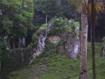 In modern history, Tikal
was explored in 1848, and again in 1877. It was completely overgrown
with
dense jungle, which had to be cut away first before any excavation could
begin. In modern history, Tikal
was explored in 1848, and again in 1877. It was completely overgrown
with
dense jungle, which had to be cut away first before any excavation could
begin.
 Scientific research began in earnest in 1881. Today,
excavations are continuing. It is estimated that it would take 20
years of heavy work to uncover the mapped surface-situated structures in
central Tikal alone, and a 100 years to find out what underlies just these
structures. Scientific research began in earnest in 1881. Today,
excavations are continuing. It is estimated that it would take 20
years of heavy work to uncover the mapped surface-situated structures in
central Tikal alone, and a 100 years to find out what underlies just these
structures.
- -
-
|
TIKAL TRIP
RECOMMENDATIONS
If you're planning a trip to Tikal,
check out our Tikal Trip
Recommendations
which includes information and prices on recommended lodging and
transportation, logistics and trip tips in general. |
[ Top of page ] |
|
|
|
TIKAL TRIP Read text at left first. This Slide Show has
great narrative so be sure to click on the first picture to start
the show.
You may have to scroll down on some pictures,
we apologize for this inconvenience.
View
SLIDE SHOW of Tikal Trip
|
|
|
DECEMBER 21, 2012:
This marks the end of the Maya Long Count calendar and the Maya
believed that the world would come to an end on this day. This
happens to also be the winter solstice, and furthermore the path of the
sun (ecliptic) crosses the Equator of the Milky Way - an event not to be
repeated for eons. It is remarkable how they could precisely
predict this so far in the future. In short, the Maya Long Count
calendar begins on August 11, 3114 BC (converted to Gregorian
calendar). Related to certain astronomical cycles, and based upon
nested cycles of days multiplied at each level by that key Mayan number
"20", the Great Cycle is 5,125.36 years long, ending on December 21, 2012.
Today, this calendar is still followed by Mayas in the Guatemalan
highlands. |
|
|
|
|
MAYA
RUINS of QUIRIGUA,
GUATEMALA
 Just
over an hour's drive from the Rio Dulce are the Quiriguá
ruins set in a beautifully maintained, tropical park
atmosphere. Compared to Copán
and Tikal, this ruin area is very small so it can be seen in a short day
trip. Just
over an hour's drive from the Rio Dulce are the Quiriguá
ruins set in a beautifully maintained, tropical park
atmosphere. Compared to Copán
and Tikal, this ruin area is very small so it can be seen in a short day
trip.
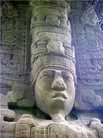
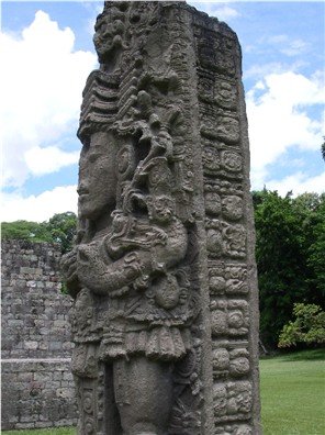
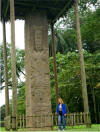
SIGNIFICANCE: Quiriguá
is known for its very tall and intricately carved stelae - huge
tombstone-type things - the largest known in the Mayan world. The
largest measures 36 feet
(26 ft. above ground and about 10 ft. below ground) and weighs approximately
130,000 pounds. There is an acropolis but it is insignificant compared
to Tikal's or Copán's.
HISTORY: Quiriguá is
situated close to the Rio Motagua with its large beds
 of
brown sandstone, making it possible to garner huge blocks for carving stelae. Sandstone is soft when
initially cut, but becomes hard as it dries. Quiriguá was a dependent
of nearby Copán during much of the Classic period (AD 200-1000) and thus had
use of their expert artisans for guidance. Eventually Cauac Sky became Quiriguá's
leader, decided to become independent of Copán
(that's when Copán's
18 Rabbit was beheaded), and began commissioning stonework. For 38
years Quiriguá's stonecutters turned out huge stelae and zoomorphs
(animal-creatures). Seven of the stelae are of Cauac Sky, including
the tallest. of
brown sandstone, making it possible to garner huge blocks for carving stelae. Sandstone is soft when
initially cut, but becomes hard as it dries. Quiriguá was a dependent
of nearby Copán during much of the Classic period (AD 200-1000) and thus had
use of their expert artisans for guidance. Eventually Cauac Sky became Quiriguá's
leader, decided to become independent of Copán
(that's when Copán's
18 Rabbit was beheaded), and began commissioning stonework. For 38
years Quiriguá's stonecutters turned out huge stelae and zoomorphs
(animal-creatures). Seven of the stelae are of Cauac Sky, including
the tallest.
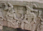
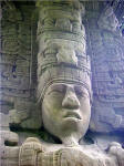
The stelae are carved with the
rulers' images. Of special note on the stelae here are the headdresses, the
goatees (which is unique), the staffs of office held in the rulers' hands,
and the hieroglyphics on the sides of the stelae chronicling his life and
achievements. There are also zoomorphs depicting frogs, tortoises,
jaguars, serpents as well as mythological creatures. An Asian
influence can be seen attesting to their probable cultural presence
thousands of years ago.
 Quiriguá
was initially discovered in 1840; excavations began in the late 1800's; in
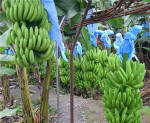
early 1900's the land around it was sold to United Fruit Company (Chiquita) so it is
surrounded today by banana plantations. It is one of the three Unesco
World Heritage Sites in Guatemala, the others being Tikal and Antigua. Quiriguá
was initially discovered in 1840; excavations began in the late 1800's; in
early 1900's the land around it was sold to United Fruit Company (Chiquita) so it is
surrounded today by banana plantations. It is one of the three Unesco
World Heritage Sites in Guatemala, the others being Tikal and Antigua.
- -
-
|
QUIRIGUA TRIP RECOMMENDATIONS
A group of us from the
Rio Dulce hired a reasonably priced private van from Otitours in
Fronteras. The drive was a little over an hour. If you
stretch it, you can spend 3 hours at the ruins, so this is an easy day
trip. We understand you can also grab a bus to get you to the
area, then find a cab or take a long walk to the ruins. There is a small cafe
at the site (we didn't eat there). This would be a good place
to bring a picnic lunch as there are picnic tables and the grounds are
lovely. (Jan. 2008) |
[ Top of page ]
[ Return to P/J page 29,
Quiriguá ] |
|
|
|
QUIRIGUA TRIP Read text at left first.
View
SLIDE SHOW of Quiriguá Trip
|
| |
|
|
|
|
Guatemala continued . .
. |
[ Back ] [ Home ] [ Up ] [ Next ] [Tikal
Trip Recommendations ] [ Top of page ]
|