|
[ Back ] [ Home ] [ Up ] [ Next ]
El Salvador - Nicaragua - Costa Rica
Trip Recommendations
|
Most pictures have
captions, so be sure to move cursor over pictures.
There are several Slide
Shows below - they all have captions so you may need to advance pictures
manually.
Click any picture to
enlarge; then close out of that window to return here. |
|
COSTA
RICA
|
OUR ITINERARY |
|
TOTAL DAYS: |
23 |
|
DESTINATIONS: |
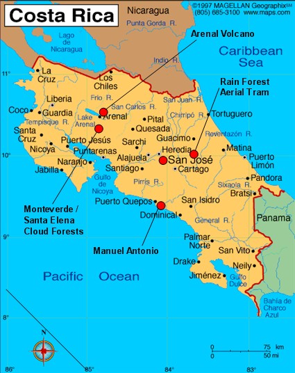
San Jose (home
base) - Arenal Volcano - Monteverde/Santa Elena Cloud Forest Reserves - Manuel Antonio
Nat'l Park
- Rain Forest Aerial Tram "Atlantic" (day trip)
(see map below) |
|
HIGHLIGHTS:
|
Combined Arenal/Monteverde circuit provided
spectacular scenery with lots of wildlife and things to do; staying at
the Arenal Observatory Lodge at the base of this active volcano was
unforgettable. However, the wildlife at Manuel Antonio was more plentiful. |
|
COSTA RICA |
|
POPULATION: |
4 million (1/3 under age 15);
10% of the population are Nicaraguans |
|
AREA: |
20,000 sq mi
(slightly smaller than West Virginia);
27% of country is
"protected" land |
|
CAPITAL: |
San Jose;
in 1884, it was the 3rd city in the world to get electricity (after
Paris and New York City) |
|
LITERACY RATE: |
96% |
|
MINIMUM WAGE: |
18% of population lives below poverty level (relatively
small due to
lack of civil war, strong exports and stronger tourism);
minimum wage is $375/mo (source: Wikipedia) |
|
ECONOMY: |
75% of economy is from tourism;
Exports: Coffee, corn, sugar, palm oil |
|
OFFICIAL
CURRENCY: |
Colón
(US$1 =
512
Colones) |
|
VOLCANOES: |
Series of volcanic mountains runs NW-SE and includes
Arenal, one of the 10 most active volcanoes in the world |
|
MILITARY: |
Has NO military - was abolished in the 1940s |
|
OTHER: |
Prostitution is legal |
Of all the Central
American countries, Costa Rica is considered to be the most sophisticated.
The standard of living in Costa Rica is well above all its neighbors, so prices
are considerably higher than what we had been used to in other Central
American countries (except Belize) (plus their sales and hotel taxes are high).
|
SEX TOURISM
Considering how “sophisticated” Costa Rica is
compared to the rest of Central America, we were surprised
to find out that prostitution is legal for persons over the
age of 18, and is centered around San Jose. In our
nice but not fancy hotel, everyday we saw nice-looking young
women in
skimpy outfits hanging around the bar with gringos, and saw
them come and go from rooms. Our upscale neighborhood also
had several “massage and spa” parlors and hotels, some for
“men only”. The pleasant public parks are fine during the
day, but at dusk turn into prostitution hangouts and are
considered dangerous at night. A bigger problem, though, is
that this has fostered sexual exploitation of children, and
Costa Rica has a big campaign on to crack down on
offenders. (Hard to do when this is the only way some
families can “make a living”). Costa Rica has become a
haven for wealthy American men to come and have “fun”. So
if your honey tells you he’s going on a sport fishing trip with
the guys to Costa Rica . . . |
|
 Costa Rica is a small
country bordered by the Pacific on the west, the Caribbean on the east,
Nicaragua to the north and Panama to the south. The volcanic range
that runs down the center of Costa Rica splits the country into 2 halves, each
with markedly different climates, vegetation and wildlife.
Furthermore, due to its unique geography and wide range of habitats
(eons ago it served as a "transit bridge" between the North
American continent and the South American continent) it boasts the most
diverse collection of flora and fauna of any country in the world*.
It is a very popular tourist destination for nature lovers and outdoor
adventure seekers - so much so that high/dry season (December - April)
will have you on waiting lists to enter the more popular national parks
and other attractions. We traveled during the low/rainy season and
would definitely recommend it. (See
Traveling During Rainy Season under our Trip Recommendations for
more discussion on when to travel.) Costa Rica is a small
country bordered by the Pacific on the west, the Caribbean on the east,
Nicaragua to the north and Panama to the south. The volcanic range
that runs down the center of Costa Rica splits the country into 2 halves, each
with markedly different climates, vegetation and wildlife.
Furthermore, due to its unique geography and wide range of habitats
(eons ago it served as a "transit bridge" between the North
American continent and the South American continent) it boasts the most
diverse collection of flora and fauna of any country in the world*.
It is a very popular tourist destination for nature lovers and outdoor
adventure seekers - so much so that high/dry season (December - April)
will have you on waiting lists to enter the more popular national parks
and other attractions. We traveled during the low/rainy season and
would definitely recommend it. (See
Traveling During Rainy Season under our Trip Recommendations for
more discussion on when to travel.)
 Twenty-seven
percent of the land is
protected in national parks, protected zones and privately owned
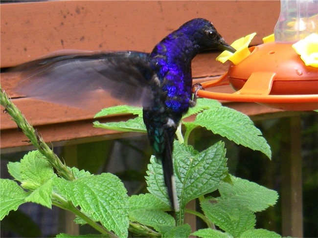
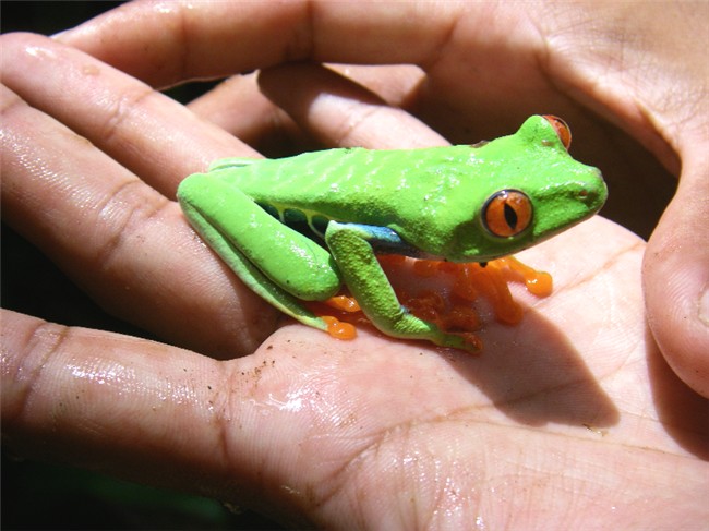
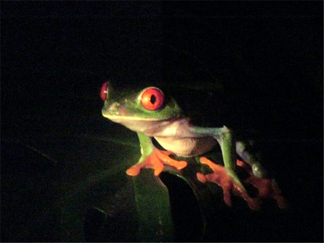
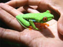
reserves. Costa Rica is home to colorful frogs including Costa Rica's
poster child, the red-eyed tree frog, as well as the
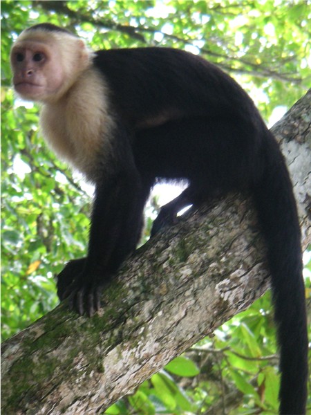
red and the green poison dart frogs, sloths, monkeys (howler, spider, white face capuchin,
squirrel), to name just a
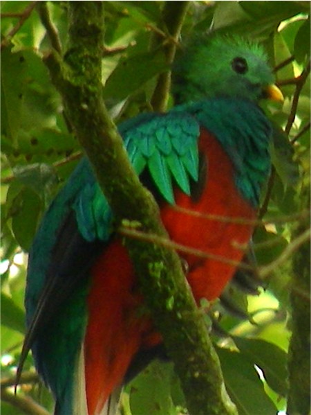
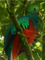
few. Birders from all over the world come here to see the rare
resplendent
quetzal (the most cherished bird in Central America),
toucans, macaws,
parrots, mot-mot. Throughout Costa Rica there's more than ample
opportunity to visit butterfly and hummingbird gardens, ranariums (frog aquariums),
serpentariums (snake aquariums), insect Twenty-seven
percent of the land is
protected in national parks, protected zones and privately owned
reserves. Costa Rica is home to colorful frogs including Costa Rica's
poster child, the red-eyed tree frog, as well as the
red and the green poison dart frogs, sloths, monkeys (howler, spider, white face capuchin,
squirrel), to name just a
few. Birders from all over the world come here to see the rare
resplendent
quetzal (the most cherished bird in Central America),
toucans, macaws,
parrots, mot-mot. Throughout Costa Rica there's more than ample
opportunity to visit butterfly and hummingbird gardens, ranariums (frog aquariums),
serpentariums (snake aquariums), insect
 museums,
botanical and orchid gardens, canopy zip line tours, aerial trams,
hanging bridges,
etc., etc. There is turtle watching (leatherback, green, olive ridley, hawksbill) on both coasts. Hiking, backpacking, river
kayaking/raft trips, horseback riding, sport fishing and surfing are all very popular here, as well as
4-wheel driving. And last but not least is the abundance of
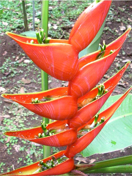
colorful tropical flowers and plants, so many varieties of orchid, heliconia
(bird of paradise), ginger, ferns, epiphytes, bromeliads and strangler figs. The above
only scratches the surface of what we saw. museums,
botanical and orchid gardens, canopy zip line tours, aerial trams,
hanging bridges,
etc., etc. There is turtle watching (leatherback, green, olive ridley, hawksbill) on both coasts. Hiking, backpacking, river
kayaking/raft trips, horseback riding, sport fishing and surfing are all very popular here, as well as
4-wheel driving. And last but not least is the abundance of
colorful tropical flowers and plants, so many varieties of orchid, heliconia
(bird of paradise), ginger, ferns, epiphytes, bromeliads and strangler figs. The above
only scratches the surface of what we saw.
*
Measured in terms of number of species per 10,000 sq km (3,860 sq mi), Costa Rica has
615 species, compared to Rwanda with 596 and the USA with 104. Source: Lonely Planet
|
BRIEF HISTORY
of COSTA RICA:
Columbus discovered this land in
1502 from the Caribbean coast and mistakenly saw what he thought was
an abundance of gold, thus "la costa rica". Costa Rica avoided having to
fight for their independence from Spain, then Mexico, by being
situated on the territorial outskirts and having little natural
resources to exploit. The 1800's coffee cultivation propelled
Costa Rica
into the wealthiest area in the region, and from then on coffee barons
would play a part in the country's politics ever after. To
export coffee from the Caribbean coast, a
 railroad had to be built
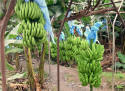
from the central highlands across fertile land. Banana crops
were planted along the railroad to provide cheap food for the workers.
On a whim, bananas were shipped to New Orleans, where they became the
craze, creating the "yellow gold" for Costa Rica, surpassing coffee exports by
the early 1900's. As with other Central American countries,
American exporter United Fruit Company (aka Chiquita Banana) got involved and greatly
affected (not necessarily for the better) the country's economics,
politics and ethnic mix. railroad had to be built
from the central highlands across fertile land. Banana crops
were planted along the railroad to provide cheap food for the workers.
On a whim, bananas were shipped to New Orleans, where they became the
craze, creating the "yellow gold" for Costa Rica, surpassing coffee exports by
the early 1900's. As with other Central American countries,
American exporter United Fruit Company (aka Chiquita Banana) got involved and greatly
affected (not necessarily for the better) the country's economics,
politics and ethnic mix.
Costa Rica has had its bit of civil war,
violence, dictatorship, armed struggle for power and related
executions. Coffee barons, the military and the church have been
very influential. In the 1940s, Costa Rica was coming into its own as a
democracy. Under coffee baron Jose Figueres Ferror's leadership
the wealthy were taxed; national banks created; full citizenship and
voting rights given to women, blacks, indigenous and Chinese
minorities; AND the military was abolished saying that it was a threat
to Costa Rica's politics. His revolutionary regime is the foundation
today of Costa Rica's unique "unarmed democracy".
However, this concept has been
tested. As we've seen from the recent history of Guatemala, El
Salvador and Nicaragua, the U.S. was actively opposed to the leftist
politics in these countries. (Although Costa Rican politics are leftist,
it's considered reformist, not revolutionary.) Again, the U.S.
had to meddle. In making another go at financing the Nicaraguan
Contras in order to thwart the Sandinistas (it wasn't going well for
the U.S.), the U.S. dragged the reluctant Costa Rica into their conflict.
The Contras, CIA and U.S. military set up shop and built a secret
jungle airstrip in northern Costa Rica, bribing Costa Rica with hush money.
Oliver North trafficked illegal narcotics through the region to
finance the operations. (Of course this didn't do much to help
the already strained relations between Costa Rica and Nicaragua.)
Because of this, there was an outcry to reestablish the military, but
the 1986 election of Oscar Aria reaffirmed the "unarmed democracy"
credo. President Arias was also the person behind the Peace
Treaty (which Pres. Reagan pooh-poohed) which finally ended the civil
wars and brought peace to Central America after many decades.
|
|
|
- - -
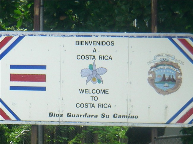
 We're
now leaving the
CA-4 countries so clearing out of Nicaragua and
crossing the border into Costa Rica is a lengthier, 2-hour ordeal of
waiting in lines. On the road again, we notice the roadways are
cleaner and apparently there are some sort of building restrictions as
houses, fences, utility poles etc. are built way back from the road, as if
to allow for future road expansion. Also, Costa Rica's ecology-mindedness was
obvious from the moment we crossed the border as there were more trees - not
having been cut for lumber. After a much longer than normal (due to
fatal traffic accident, torrential rains and rush hour traffic) but
comfortable bus ride, we arrive in San Jose located in a valley in the
center of the country. We're
now leaving the
CA-4 countries so clearing out of Nicaragua and
crossing the border into Costa Rica is a lengthier, 2-hour ordeal of
waiting in lines. On the road again, we notice the roadways are
cleaner and apparently there are some sort of building restrictions as
houses, fences, utility poles etc. are built way back from the road, as if
to allow for future road expansion. Also, Costa Rica's ecology-mindedness was
obvious from the moment we crossed the border as there were more trees - not
having been cut for lumber. After a much longer than normal (due to
fatal traffic accident, torrential rains and rush hour traffic) but
comfortable bus ride, we arrive in San Jose located in a valley in the
center of the country.
- - -
 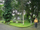 San
Jose,
the capital (pop. city 350,000, metro 1.5
million),
is considered to be the most cosmopolitan of all Central American cities.
It is a delightful, thriving city, with pleasant temperatures (3,500 ft.
elevation), although rain in the afternoon is to be expected this time of
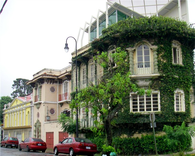
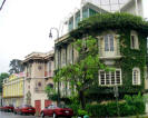
year. We stayed in the safe, nice neighborhood of Barrio Amόn,
which is a mix of the old wealthy coffee baron homes, most converted into
nice hotels (including where we stayed) and restaurants, along with a
smattering of modern construction. San Jose has street names, but does not use street addresses
for anything: It's "at the corner of ___ avenue and ___ street",
or, "____ meters southwest of the Catholic Church". So far it's
worked for them. We've seen this used in small towns, but never in a
city the size of San Jose! We used San Jose as our home base in
between side trips, allowing us to explore a little at a time. San
Jose,
the capital (pop. city 350,000, metro 1.5
million),
is considered to be the most cosmopolitan of all Central American cities.
It is a delightful, thriving city, with pleasant temperatures (3,500 ft.
elevation), although rain in the afternoon is to be expected this time of
year. We stayed in the safe, nice neighborhood of Barrio Amόn,
which is a mix of the old wealthy coffee baron homes, most converted into
nice hotels (including where we stayed) and restaurants, along with a
smattering of modern construction. San Jose has street names, but does not use street addresses
for anything: It's "at the corner of ___ avenue and ___ street",
or, "____ meters southwest of the Catholic Church". So far it's
worked for them. We've seen this used in small towns, but never in a
city the size of San Jose! We used San Jose as our home base in
between side trips, allowing us to explore a little at a time.
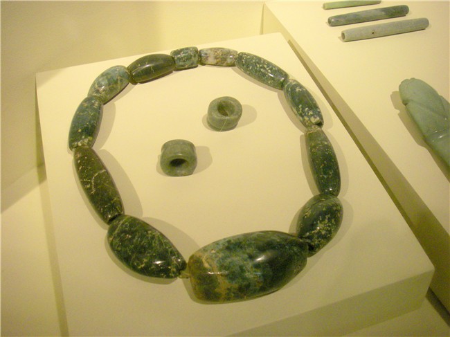
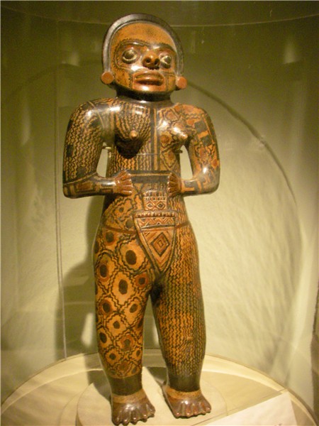
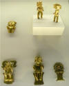
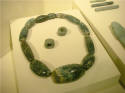  The
most famous museum is the newly relocated Jade Museum. It has
the world's largest (and nice) collection of American jade and other
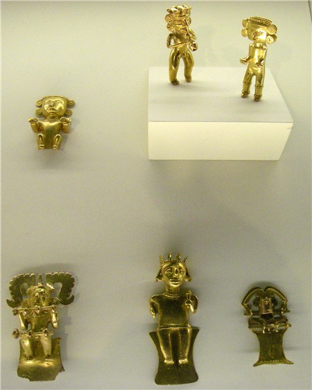
pre-Columbian ceramic and stonework artifacts. The Central Bank, who
now issues all the country's currency, owns the well-done Pre-Columbian
Gold and Numismatic Museum, with a huge glittering display of gold
pieces and artifacts. We even found the small Numismatic exhibit to
be quite interesting: The
most famous museum is the newly relocated Jade Museum. It has
the world's largest (and nice) collection of American jade and other
pre-Columbian ceramic and stonework artifacts. The Central Bank, who
now issues all the country's currency, owns the well-done Pre-Columbian
Gold and Numismatic Museum, with a huge glittering display of gold
pieces and artifacts. We even found the small Numismatic exhibit to
be quite interesting:
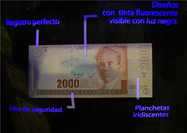
 In
the 1800's due to a shortage, coins from other countries were stamped and
used; "private" money (chips, tokens, coupons, etc.) were used to pay
plantation workers; the "colon" became the new currency (previously it was
the peso) in 1892 in honor of the 400th-year
anniversary of Christopher Columbus' arrival; a black-light display shows the safety In
the 1800's due to a shortage, coins from other countries were stamped and
used; "private" money (chips, tokens, coupons, etc.) were used to pay
plantation workers; the "colon" became the new currency (previously it was
the peso) in 1892 in honor of the 400th-year
anniversary of Christopher Columbus' arrival; a black-light display shows the safety
 features
on their paper money and you can inspect your own bills. (Most retail stores hold your money under a black-light
to verify it's authenticity; for U.S. dollars, they run a special marking
pen across the bill to verify.) The National Theater is
considered to be San Jose's most impressive public building, with beautiful
marble statues and copious amounts of gold leaf; a large famous painting
from Italy depicting banana harvesting – but obviously artist had never
witnessed such a thing;
theater's main floor rises level with the stage for social functions; this
theater was the 3rd location in the world to have electricity (after Paris
and New York City). All museums had English signage (which is
unusual). features
on their paper money and you can inspect your own bills. (Most retail stores hold your money under a black-light
to verify it's authenticity; for U.S. dollars, they run a special marking
pen across the bill to verify.) The National Theater is
considered to be San Jose's most impressive public building, with beautiful
marble statues and copious amounts of gold leaf; a large famous painting
from Italy depicting banana harvesting – but obviously artist had never
witnessed such a thing;
theater's main floor rises level with the stage for social functions; this
theater was the 3rd location in the world to have electricity (after Paris
and New York City). All museums had English signage (which is
unusual).
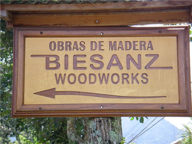
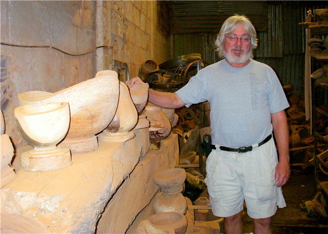
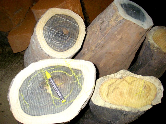
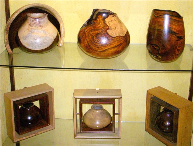
Costa Rica is known for its beautiful hardwoods and
wonderful craftsmanship. A morning trip to nearby Escazú took us to
Biesanz Woodworks, the workshop and store of internationally renowned wood craftsman Barry Biesanz. His work is
delicate and high quality, totally handmade, each piece designed around the
natural lines and shape of the wood so each piece is very unique. His
signature bowl pieces are so delicate that the wood is actually translucent
when held up to the light (cost of single bowl shown above is US$700).
We bought a "thin", but not translucent, bowl.
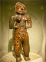
In the neighborhood we were staying is the
Galeria Namu
that has a superb collection of art from the small but diverse indigenous
culture of Costa Rica. This small store is packed with high quality
arts and crafts from the various tribes, and gave us a quickie education
about traditions better than anything else we saw. We fell in love
with the Boruca “Diablitos” ceremonial masks (awesome way beyond any Guatemalan mask) and bought 2 (shipped to Houston).
See box below. The store practices “free trade”,
which means they buy the pieces directly from the artist (instead of on
consignment); sales proceeds go 50% to the artist and 50% to the store. We
discussed having them arrange a trip for us to visit the Boruca tribe (pop.
2,000), but the rainy season was making reliable and safe transportation too
iffy.
| BORUCA CEREMONIAL MASKS
Boruca (Brunka) (pop. 2,000) is one of the eight
indigenous pueblos in Costa Rica, located in the southwest part of the
country. They fought against the Spanish invasion, and from that
has come the Fiesta de los Diablitos (festival of the "little devils") ceremony. Each year
from December 30 - January 2, they reenact the invasion: One person dresses up
as the toro with a bull mask and costume (to represent the Spanish
conquistadors) and all other
tribal members dress up with diablito masks ("little devils" to
represent the natives). There is back and forth "fighting" between the bull and
the devils, with the bull slaying all the diablitos, but on the
last day the little devils resurrect and "kill" the bull
representing their defeat of the Spaniards.
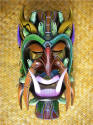 All
masks are made from ONE solid piece of wood, originally out of cedar, but
over time lighter-weight balsa wood was used as more practical for wearing.
The masks have evolved over time: Original masks were crude devil (or
bull) faces; then they became more artistic and started painting them; then
they started adding ecological themes to them (as seen on our mask at left).
These evolved into ecologically-themed masks with a smaller shaman
mask worked into it - we bought one of these, too, (forgot to take a picture
before having it shipped to Houston) with lots of colorful
Costa Rican frogs on a tree overlaying a small shaman mask - frogs represent
fertility, but we bought it for the colorful and incredibly, intricate 3-dimensional
work. All
masks are made from ONE solid piece of wood, originally out of cedar, but
over time lighter-weight balsa wood was used as more practical for wearing.
The masks have evolved over time: Original masks were crude devil (or
bull) faces; then they became more artistic and started painting them; then
they started adding ecological themes to them (as seen on our mask at left).
These evolved into ecologically-themed masks with a smaller shaman
mask worked into it - we bought one of these, too, (forgot to take a picture
before having it shipped to Houston) with lots of colorful
Costa Rican frogs on a tree overlaying a small shaman mask - frogs represent
fertility, but we bought it for the colorful and incredibly, intricate 3-dimensional
work. |
- - -
 For
our first side trip, we were able to
combine two popular areas into one trip: Arenal Volcano and the
Monteverde/Santa Elena Cloud Forest Reserves. These areas are located
several hours north of San Jose, on either side of the central mountain range,
the Continental Divide.
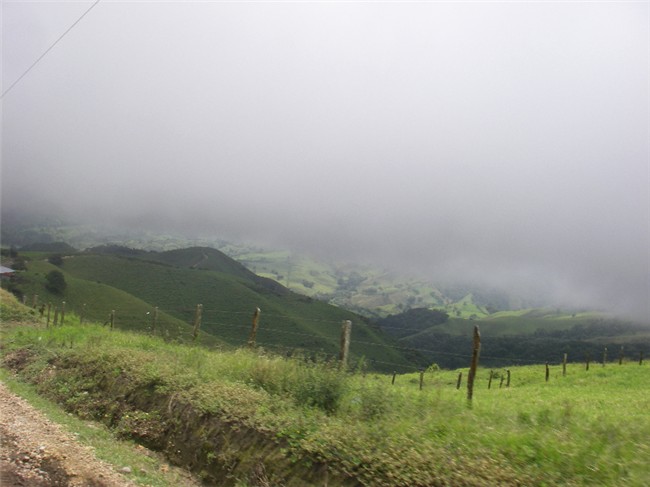
Along the road to Arenal are sections of coffee, mango, papaya, banana, corn
and commercially grown houseplants (dracaena, ferns); we travel through
parts shrouded by clouds, heavy fog and mist; cross rivers and see lots of
water falls and cascades. For
our first side trip, we were able to
combine two popular areas into one trip: Arenal Volcano and the
Monteverde/Santa Elena Cloud Forest Reserves. These areas are located
several hours north of San Jose, on either side of the central mountain range,
the Continental Divide.
Along the road to Arenal are sections of coffee, mango, papaya, banana, corn
and commercially grown houseplants (dracaena, ferns); we travel through
parts shrouded by clouds, heavy fog and mist; cross rivers and see lots of
water falls and cascades.
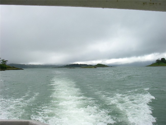
Arenal Volcano lies on the east shore of
Arenal Lake; to the south of the lake is the Monteverde/Santa Elena
reserves. Although as the crow flies Arenal and
Monteverde are close by, you cannot cross the mountain range
 that separates them (the Caribbean side from the Pacific side), so by
4-wheel drive it is a VERY ROUGH many hour drive around the other
side of the lake. Or, as we did, there is the Jeep-Boat-Jeep service
that took us across Arenal Lake. Even so, the then 22 miles by land over mountains
still took almost 2 hours by van. Our van driver told us that they have to
replace the van tires every 2-3 months (6,000-7,000 miles) and the shocks
2-3 times a year due to the naturally rough terrain of rocks, dirt and mud
ruts.
The origin of the Monteverde community is Quaker and they have intentionally left the
roads “natural” to discourage tourism and development. As we
cross over the Continental Divide, it was odd to be
able to see the Pacific Ocean and to be cold at the same time. that separates them (the Caribbean side from the Pacific side), so by
4-wheel drive it is a VERY ROUGH many hour drive around the other
side of the lake. Or, as we did, there is the Jeep-Boat-Jeep service
that took us across Arenal Lake. Even so, the then 22 miles by land over mountains
still took almost 2 hours by van. Our van driver told us that they have to
replace the van tires every 2-3 months (6,000-7,000 miles) and the shocks
2-3 times a year due to the naturally rough terrain of rocks, dirt and mud
ruts.
The origin of the Monteverde community is Quaker and they have intentionally left the
roads “natural” to discourage tourism and development. As we
cross over the Continental Divide, it was odd to be
able to see the Pacific Ocean and to be cold at the same time.
Arenal
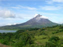 Arenal
Volcano lies just to the east of Arenal Lake, a large man-made lake which
generates a large portion of the power and irrigation for the area. The dam
at the base of the volcano was made with liquid cement so that it would
filter down through the lava rocks. There’s no pleasure craft and a little
fishing on the lake. It’s quite a view seeing the volcano and lake side by
side. Arenal
Volcano lies just to the east of Arenal Lake, a large man-made lake which
generates a large portion of the power and irrigation for the area. The dam
at the base of the volcano was made with liquid cement so that it would
filter down through the lava rocks. There’s no pleasure craft and a little
fishing on the lake. It’s quite a view seeing the volcano and lake side by
side.
The biggest town in the Arenal area is
La Fortuna, built up for the tourist trade (paved road, everybody speaks
English, no burglar bars), but unfortunately it now lies on the wrong side of the volcano
(wrong, as in no lava flow view). So we head over to the "right" side
of the volcano in our rented 4-wheel drive which is a MUST for this terrain,
especially in rainy season. All around the area are numerous hot springs,
the glitz of which is described as Caesar’s Palace-esque, but with the
daytime temps being hot and entrance fees up to $29/person we passed – in
retrospect, we probably should have gone just to see what all the hype is
about. The area also has lots of water attractions and various eco-centers,
where we saw sloths, cute colorful frogs and the like living in their natural
habitat among the usual but wide variety of lush tropical flowers and
plants. But the main draw is the volcano itself.
|
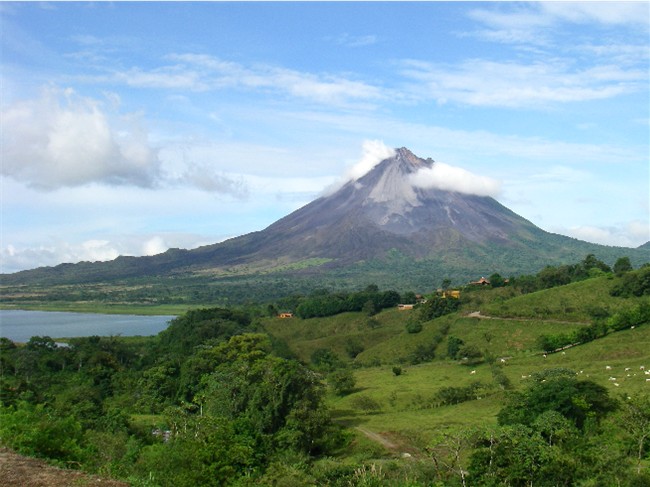
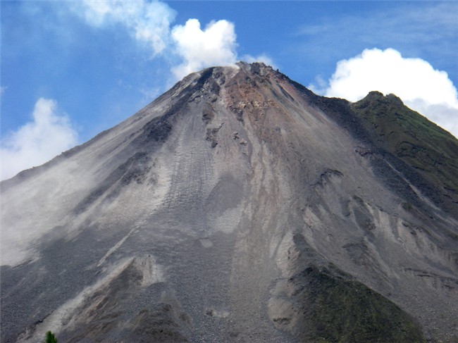
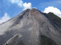 Arenal
Volcano,
one of the 10 most active volcanoes in the world is identified as “pyroclastic”, meaning it
spews hot ash, rock fragments, lava and gases. Hot liquid magma rises
inside the volcano, as it spills over the crater’s edge the cold air cools
it to lava and it tumbles down the side as hard rock. It erupted for the
first time in 400 years in 1968, killing 87 people (most from poisonous gas)
and 45,000 cows, affecting about
4.6 sq miles,
and forming “Crater D” at 5,358 ft. (Farmers had reported strange behavior
from their dogs and other farm animals prior to the eruption.) In 1984, and
peaking in 1987-’89, another crater, “C”, was formed from a particularly
harsh expulsion of incandescent basaltic rocks and ashes, today reaching
5,577 ft. Arenal has remained active, and from time to time its lava flow
changes directions, much to the dismay of fancy resorts built on the “wrong”
side: In 1993, it flowed west/northwest; in 2000 changed to the north; and
in April 2007 began flowing to the southwest. Arenal
Volcano,
one of the 10 most active volcanoes in the world is identified as “pyroclastic”, meaning it
spews hot ash, rock fragments, lava and gases. Hot liquid magma rises
inside the volcano, as it spills over the crater’s edge the cold air cools
it to lava and it tumbles down the side as hard rock. It erupted for the
first time in 400 years in 1968, killing 87 people (most from poisonous gas)
and 45,000 cows, affecting about
4.6 sq miles,
and forming “Crater D” at 5,358 ft. (Farmers had reported strange behavior
from their dogs and other farm animals prior to the eruption.) In 1984, and
peaking in 1987-’89, another crater, “C”, was formed from a particularly
harsh expulsion of incandescent basaltic rocks and ashes, today reaching
5,577 ft. Arenal has remained active, and from time to time its lava flow
changes directions, much to the dismay of fancy resorts built on the “wrong”
side: In 1993, it flowed west/northwest; in 2000 changed to the north; and
in April 2007 began flowing to the southwest.
 We called ahead to the Arenal
Observatory to find out which direction it was flowing before deciding where
to stay. We stayed at three different places – all with spectacular lava views
- but the highlight was staying at the Arenal Observatory Lodge, which was
built in 1986 to house the Smithsonian-Earthwatch scientists. It is located
less than 2 miles south of Arenal’s summit - in a high risk zone. Our
nice room had an
up-close and personal view of Arenal through our picture window from our
bed! We called ahead to the Arenal
Observatory to find out which direction it was flowing before deciding where
to stay. We stayed at three different places – all with spectacular lava views
- but the highlight was staying at the Arenal Observatory Lodge, which was
built in 1986 to house the Smithsonian-Earthwatch scientists. It is located
less than 2 miles south of Arenal’s summit - in a high risk zone. Our
nice room had an
up-close and personal view of Arenal through our picture window from our
bed!
 You might envision a rather rustic place for the scientists, but we
were pleasantly surprised: Beautiful spacious grounds meticulously landscaped with
flowering trees and plants – lots of species of heliconia (bird of
paradise), ginger, hibiscus and orchids to name just a few - and several miles of hiking/nature
trails through the forests and along streams; a pool and huge covered jacuzzi set back in the pine forest; a
wonderful observation deck (with a view of Arenal Lake, too); a good
restaurant/bar off the deck; an interesting mini-museum with a seismometer; and different
levels of accommodations scattered around the property. We stopped by for a
day visit only and decided we had to spend the night and take advantage of
the awesome view and nice amenities (traveling during low season allowed us
to remain flexible and spontaneous with our plans). You might envision a rather rustic place for the scientists, but we
were pleasantly surprised: Beautiful spacious grounds meticulously landscaped with
flowering trees and plants – lots of species of heliconia (bird of
paradise), ginger, hibiscus and orchids to name just a few - and several miles of hiking/nature
trails through the forests and along streams; a pool and huge covered jacuzzi set back in the pine forest; a
wonderful observation deck (with a view of Arenal Lake, too); a good
restaurant/bar off the deck; an interesting mini-museum with a seismometer; and different
levels of accommodations scattered around the property. We stopped by for a
day visit only and decided we had to spend the night and take advantage of
the awesome view and nice amenities (traveling during low season allowed us
to remain flexible and spontaneous with our plans).
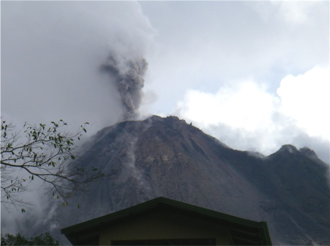
 After years of “silence”, in 2005 loud
explosions resumed. During a 6-month observation period, there was an
average of 17 explosions per day projecting rocks several hundred feet and up to
over a mile on rare occasions, and 42 pyroclastic eruptions per day.
During our stay at the Observatory, After years of “silence”, in 2005 loud
explosions resumed. During a 6-month observation period, there was an
average of 17 explosions per day projecting rocks several hundred feet and up to
over a mile on rare occasions, and 42 pyroclastic eruptions per day.
During our stay at the Observatory,
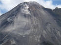 the
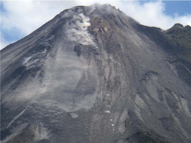
low grumble of the volcano provided constant background noise, and every few hours we’d hear a noisy explosion and see a big
poof of cauliflower-shaped ash clouds over the summit.
During the day, we could
easily see individual spewed lava rocks crash, then roll down the crater’s
side, kicking up ash, leaving vertical “dashed lines”.
These are visible in
our photos (enlarge photo at right), as well as vents where steam/gases are escaping. At night, the
lava the
low grumble of the volcano provided constant background noise, and every few hours we’d hear a noisy explosion and see a big
poof of cauliflower-shaped ash clouds over the summit.
During the day, we could
easily see individual spewed lava rocks crash, then roll down the crater’s
side, kicking up ash, leaving vertical “dashed lines”.
These are visible in
our photos (enlarge photo at right), as well as vents where steam/gases are escaping. At night, the
lava
 rocks are visibly red hot, and can still be
easily seen skipping,
breaking apart and creating several “dotted lines” down the slope (difficult
to photo in the dark, but got a few). rocks are visibly red hot, and can still be
easily seen skipping,
breaking apart and creating several “dotted lines” down the slope (difficult
to photo in the dark, but got a few).
We did a dusk/night hike to the new
(1998) lava fields, where we should have had a very up close view of the
flowing lava. However, rain and fog obscured the red view.
|
- - -
|
|
Monteverde
/ Santa
Elena
Cloud
Forests
The Continental Divide, which runs from
Canada to Argentina, separates the
 Atlantic (Caribbean) from the Pacific
Oceans, thereby creating two different ecosystems. This area in the cloud
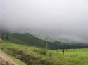
forests is subject to a fair amount of moisture (clouds, mist, rain) and as
such is, simply put, lush and green. The main attractions here are the cloud
forests, each comprising different ecosystems: The Monteverde Cloud
Forest Biological Reserve is on the Caribbean side, and the Santa Elena Cloud
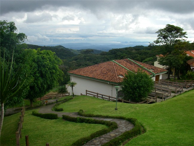
Forest Reserve is on the Pacific side. From a lookout point in the Monteverde
Reserve Atlantic (Caribbean) from the Pacific
Oceans, thereby creating two different ecosystems. This area in the cloud
forests is subject to a fair amount of moisture (clouds, mist, rain) and as
such is, simply put, lush and green. The main attractions here are the cloud
forests, each comprising different ecosystems: The Monteverde Cloud
Forest Biological Reserve is on the Caribbean side, and the Santa Elena Cloud
Forest Reserve is on the Pacific side. From a lookout point in the Monteverde
Reserve
 one
can see the Caribbean and Pacific simultaneously; and from
Santa Elena Reserve Arenal
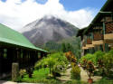
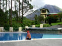
Volcano is visible - both on a clear day (good luck in the cloud
forest). From our hotel located below the reserves (pictured), we did have a great view of
the Pacific, and the Gulf and Peninsula of Nicoya. As happens
occasionally when traveling during low season, we were upgraded gratis to a
luxury room/view. one
can see the Caribbean and Pacific simultaneously; and from
Santa Elena Reserve Arenal
Volcano is visible - both on a clear day (good luck in the cloud
forest). From our hotel located below the reserves (pictured), we did have a great view of
the Pacific, and the Gulf and Peninsula of Nicoya. As happens
occasionally when traveling during low season, we were upgraded gratis to a
luxury room/view.
These cloud forest reserves are huge tourist
attractions during the
 high
season and visitors find themselves on waiting lists to enter (we were told Monteverde
allows a maximum of 150 visitors at a time). But for us
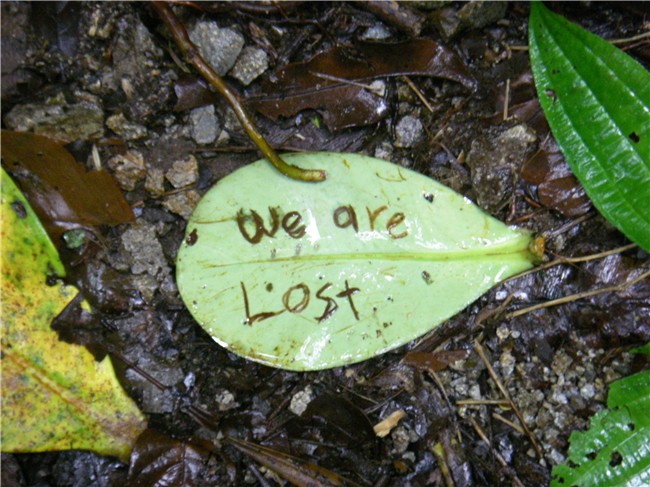
going during low season, we practically had both parks all to ourselves –
very nice indeed to be “lost” deep in the still and quietness of the forest
with our heads literally in the clouds! high
season and visitors find themselves on waiting lists to enter (we were told Monteverde
allows a maximum of 150 visitors at a time). But for us
going during low season, we practically had both parks all to ourselves –
very nice indeed to be “lost” deep in the still and quietness of the forest
with our heads literally in the clouds!
 Wow,
there is so much to see and do in this area, that you have to be ready to pick and choose from a multitude of
options, else one will go broke on entrance fees: Of course, the cloud
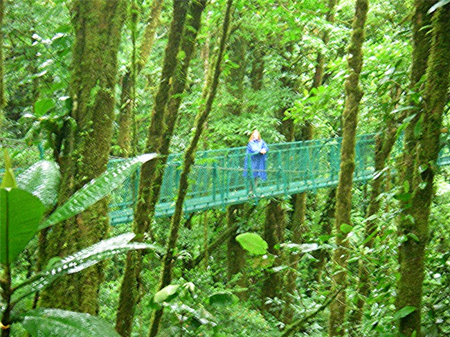
forests with its’ miles of hiking trails; aerial trams; canopy zip lines;
hanging bridges; gardens specializing in butterflies, hummingbirds, orchids;
aquariums Wow,
there is so much to see and do in this area, that you have to be ready to pick and choose from a multitude of
options, else one will go broke on entrance fees: Of course, the cloud
forests with its’ miles of hiking trails; aerial trams; canopy zip lines;
hanging bridges; gardens specializing in butterflies, hummingbirds, orchids;
aquariums
 specializing in frogs, snakes; insect museums; eco-centers;
waterfalls and springs; coffee plantation and cheese factory (Quaker
influence) tours; etc.. The wildlife is plentiful, but the absolute best way
to make sure you see it is to go with a park guide – definitely worth the money, as we probably would not have seen even 10% of what we did with a guide.
All guides carry nice spotting scopes on tripods. specializing in frogs, snakes; insect museums; eco-centers;
waterfalls and springs; coffee plantation and cheese factory (Quaker
influence) tours; etc.. The wildlife is plentiful, but the absolute best way
to make sure you see it is to go with a park guide – definitely worth the money, as we probably would not have seen even 10% of what we did with a guide.
All guides carry nice spotting scopes on tripods.
The main town is Santa Elena, although
lodging, restaurants, shops and attractions are scattered all around, within
several miles of each other. We did a guided night tour in the reserve
where the hotel is located, seeing our first mot-mot bird ever, along with
other nightly creatures such as the rarely seen olingo, coatimundi, agouti,
flying walking stick, opossum, porcupine, armadillo, and more. Our
young guide was well prepared with working flashlights for everybody, and he
carried a battery pack for his own bright flashlight.
- - -
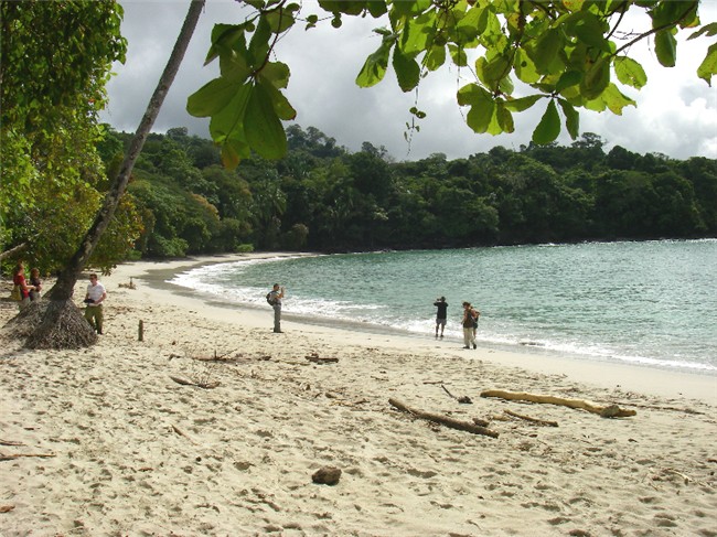
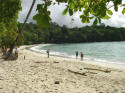 Manuel
Antonio National
Park is
located on Costa Rica’s southern
pacific coast. It is a tropical rain forest at the edge of lovely
pristine beaches and
headland outcroppings. The
amount of wildlife (in the wild) we saw
here was more plentiful than what we saw in Monteverde/Santa Elena. To cut down on
the stress that visitors impose on these animals, the park is closed Manuel
Antonio National
Park is
located on Costa Rica’s southern
pacific coast. It is a tropical rain forest at the edge of lovely
pristine beaches and
headland outcroppings. The
amount of wildlife (in the wild) we saw
here was more plentiful than what we saw in Monteverde/Santa Elena. To cut down on
the stress that visitors impose on these animals, the park is closed
 on
Mondays. As we have learned, we used an "official" park guide complete
with his spotting scope and tripod for a private tour. on
Mondays. As we have learned, we used an "official" park guide complete
with his spotting scope and tripod for a private tour.
The nearest town is Quepos, located
on the coast about 10 miles from the park,
and hotels and restaurants are all located in between, on the beach and up in
the hills (with great views). We stayed at a great hotel, Hotel
California, way up on a
hill - again, we were upgraded gratis to a pricier room with a spectacular
ocean view.
- - -
Rain
Forest
Aerial
Tram
– Atlantic
Several years ago in Dominica
(E. Caribbean), an incredibly poor island loaded with “public” fruit
 trees
all over the place, we experienced this tram and were very impressed with
the eco-mindedness that was used to build it. (It was built as a tourist
attraction for the big cruise ships.) We vowed to check out their tram in
Costa Rica (owned by the same company). In Costa Rica, they have a tram on the Pacific
coast; an hour east of San Jose, the “Atlantic” side, is another tram along
with other attractions and an overnight lodge (if you stay you can do a
night hike) in the Braulio Carrillo National Park. trees
all over the place, we experienced this tram and were very impressed with
the eco-mindedness that was used to build it. (It was built as a tourist
attraction for the big cruise ships.) We vowed to check out their tram in
Costa Rica (owned by the same company). In Costa Rica, they have a tram on the Pacific
coast; an hour east of San Jose, the “Atlantic” side, is another tram along
with other attractions and an overnight lodge (if you stay you can do a
night hike) in the Braulio Carrillo National Park.
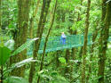
The 13 year old "Atlantic" park is situated on
1,200 acres. All towers were brought in by Nicaraguan helicopters (as
Costa Rica doesn't have much use for helicopters without a military) and all supplies were
brought in via overhead cables or by hand so as not to compromise the earth
with the weight. All “stepping stones” and stairs were made from
fallen trees. We were the first visitors in the park that morning as
we rode the aerial tram. Each car holds 8 people and a guide, and
passes through the middle of the forest and returns above the canopy level. We saw a sleeping sloth,
white-face capuchin monkeys, toucans, hawk, green eyelash snake.
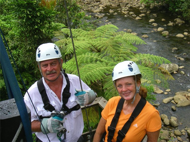
 We did
their canopy tour (zip line) which consisted of 7 zip lines interspersed
between lush nature walks. Several of the lines crossed over the scenic
river; one platform was surrounded by toucans in nearby trees. Their
equipment (and staff) were very professional – double cables and safety lines, new equipment,
helmets, a practice zip line, cables with rubber blocks to keep from cutting
into trees, and platforms with secure railings (no fear of heights on these
platforms) and built in such a way that the platform can be adjusted as the
tree grows. We did
their canopy tour (zip line) which consisted of 7 zip lines interspersed
between lush nature walks. Several of the lines crossed over the scenic
river; one platform was surrounded by toucans in nearby trees. Their
equipment (and staff) were very professional – double cables and safety lines, new equipment,
helmets, a practice zip line, cables with rubber blocks to keep from cutting
into trees, and platforms with secure railings (no fear of heights on these
platforms) and built in such a way that the platform can be adjusted as the
tree grows.
 Some
of the trees we saw grow 75 feet tall with a 40 cm diameter in 6 years.
That’s what happens when there is 25
feet of rainfall a year. Besides the aerial tram and canopy zip tour, we
saw a collection of snakes, frogs, butterflies and birds. We roused a boa
constrictor that repeatedly struck at us with lightning speed through the
glass. Some
of the trees we saw grow 75 feet tall with a 40 cm diameter in 6 years.
That’s what happens when there is 25
feet of rainfall a year. Besides the aerial tram and canopy zip tour, we
saw a collection of snakes, frogs, butterflies and birds. We roused a boa
constrictor that repeatedly struck at us with lightning speed through the
glass.
|
|
“THE
FROG POND” (Ranario) in Monteverde
This was
one of our favorite exhibits! There were large, heavily floraed
aquariums to house
the frogs and toads, which are mostly nocturnal. With the help of an
 excellent guide, we
were able to locate 36 of the 37 species, most of which
are sleeping and would otherwise be
almost impossible for an amateur to
spot.
However,
our ticket entitled us excellent guide, we
were able to locate 36 of the 37 species, most of which
are sleeping and would otherwise be
almost impossible for an amateur to
spot.
However,
our ticket entitled us
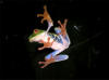 to return after dark,
and with a flashlight, we now could see the frogs and toads in full action. to return after dark,
and with a flashlight, we now could see the frogs and toads in full action.
|
|
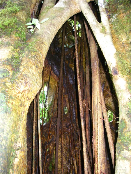
STRANGLER
FIG (FICUS) TREES
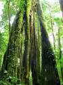 These are
a common site in the forests of Costa Rica. It starts out as a plant in the branches of a host tree, and grows air roots down to the ground. Over time,
the These are
a common site in the forests of Costa Rica. It starts out as a plant in the branches of a host tree, and grows air roots down to the ground. Over time,
the
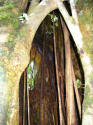 parasitic plant surrounds the host tree with its roots and eventually
“strangles” it to death, leaving the surviving parasitic tree with a hollow
center. parasitic plant surrounds the host tree with its roots and eventually
“strangles” it to death, leaving the surviving parasitic tree with a hollow
center.
|
|
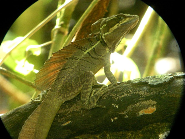
JESUS
CHRIST LIZARD
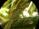 The
basilisk lizard is more commonly known as the Jesus Christ (or just JC) lizard because it literally walks on water. Males have a “crest” and “sail”
(to attract females) and a flat tail that allows them to run across water at
speeds up to 25 mph. The
basilisk lizard is more commonly known as the Jesus Christ (or just JC) lizard because it literally walks on water. Males have a “crest” and “sail”
(to attract females) and a flat tail that allows them to run across water at
speeds up to 25 mph.
|
|
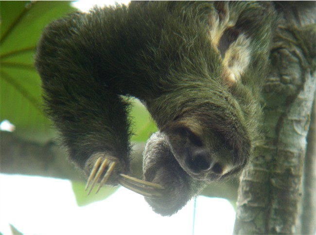
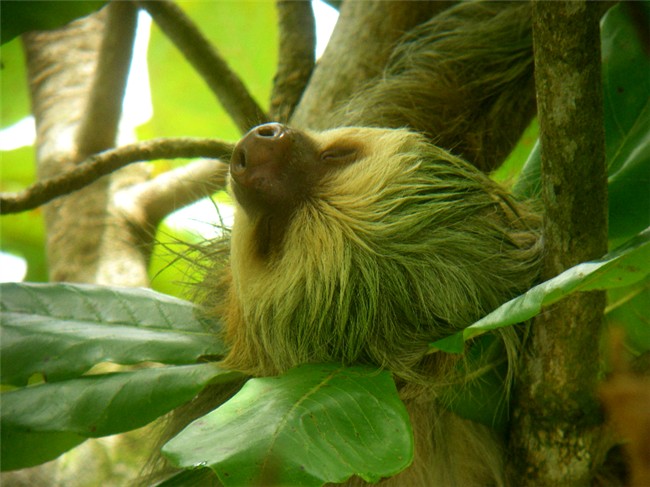
SLOTHS
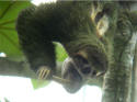 The
3-toed sloth is a day creature, moves slow, is friendlier and is
gray-brown in appearance. The 2-toed sloth is nocturnal, moves very slow,
is meaner and more The
3-toed sloth is a day creature, moves slow, is friendlier and is
gray-brown in appearance. The 2-toed sloth is nocturnal, moves very slow,
is meaner and more
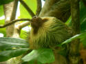 aggressive and is yellow-brown in color. All sloths eat,
sleep (at least 16 hours/ day), mate and carry baby(s) hanging upside down from
high tree branches. They do not defecate from the trees, as predators could
easily find them as they move so slow. So once or twice a week they descend
(right side up) to the ground to do their business. They eat the leaves of
some tree which “drugs” them. So their life pretty much consists of
sleeping, eating and an occasional poop. aggressive and is yellow-brown in color. All sloths eat,
sleep (at least 16 hours/ day), mate and carry baby(s) hanging upside down from
high tree branches. They do not defecate from the trees, as predators could
easily find them as they move so slow. So once or twice a week they descend
(right side up) to the ground to do their business. They eat the leaves of
some tree which “drugs” them. So their life pretty much consists of
sleeping, eating and an occasional poop.
|
|
TURTLES
Costa Rica is haven for four of the
world's seven kinds of sea turtles: olive ridley, leatherback, green and
hawksbill, all classified as endangered. Turtles are found on both the
Caribbean and Pacific coasts, and each has their own time of year when they
nest. Except for the leatherback, all return to their natal beach to lay
their eggs. Thus, protecting these beaches is of vital importance to their
continued existence.
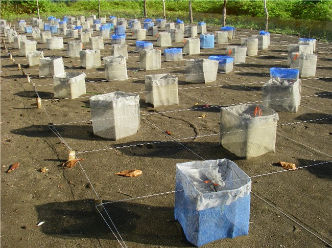
When we were in Manuel Antonio, we
visited the National Wildlife Reserve (for olive ridleys) at Punta
Mala. During the 2006-2007 season, the volunteers collected over
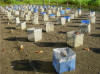 100,000 eggs, relocated 1,100 nests to a protected
area, and released over 71,000 hatchlings to the sea, of which only a small
fraction will survive 25 years to sexual maturity
to lay her own eggs. Turtles come ashore at night to lay eggs and
their nests must be moved within 5 hours before the eggs begin to harden.
Gestation period is 45-55 days, and we missed being able to help release the
season's first hatchlings by a couple of days. 100,000 eggs, relocated 1,100 nests to a protected
area, and released over 71,000 hatchlings to the sea, of which only a small
fraction will survive 25 years to sexual maturity
to lay her own eggs. Turtles come ashore at night to lay eggs and
their nests must be moved within 5 hours before the eggs begin to harden.
Gestation period is 45-55 days, and we missed being able to help release the
season's first hatchlings by a couple of days.
|
|
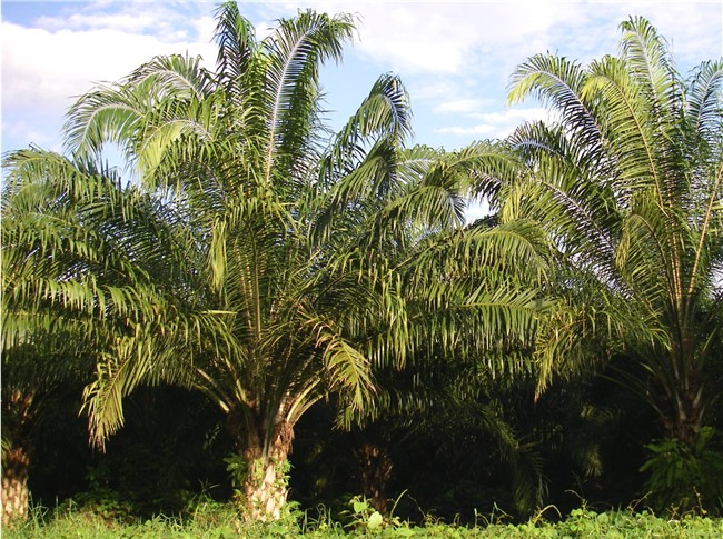
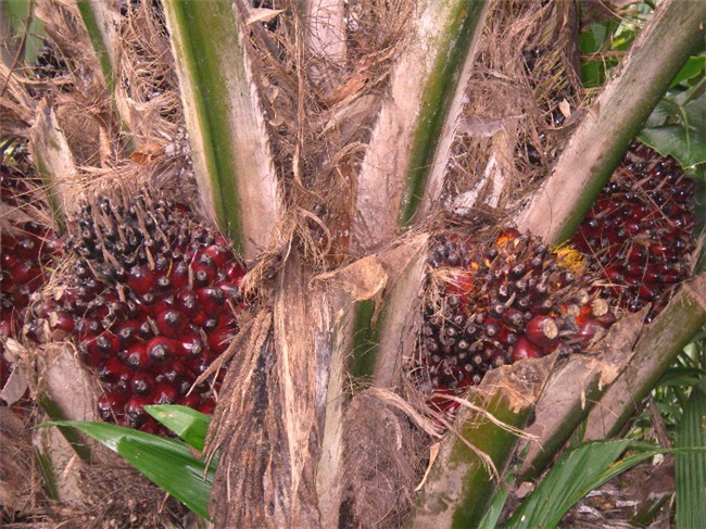
AFRICAN PALM OIL
The Quepos/Manuel
Antonio area was a main banana port in the 1940's
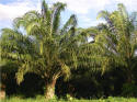 when a banana blight hit.
To supplement their economy, United Fruit Company (aka Chiquita Banana)
introduced African palm trees to the area, where today it is the primary
source of employment after commercial fishing and tourism. Compared to
the banana industry, this industry requires a smaller but more specialized
labor force. when a banana blight hit.
To supplement their economy, United Fruit Company (aka Chiquita Banana)
introduced African palm trees to the area, where today it is the primary
source of employment after commercial fishing and tourism. Compared to
the banana industry, this industry requires a smaller but more specialized
labor force.
The African palm
produces huge pods weighing up to 80 lbs., each made up of reddish fruits.
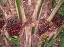 Pressing the greasy fruit pulp produces palm oil which is high in saturated
fats and is used in cooking oil, margarine and "tasty" processed foods.
Extracting and pressing the seed results in palm kernel oil used primarily
in cosmetics and soap. Approximately 24% of the fruit's weight is
turned into usable oil. Pressing the greasy fruit pulp produces palm oil which is high in saturated
fats and is used in cooking oil, margarine and "tasty" processed foods.
Extracting and pressing the seed results in palm kernel oil used primarily
in cosmetics and soap. Approximately 24% of the fruit's weight is
turned into usable oil.
|
|
|
Also see “El Salvador –
Nicaragua – Costa Rica Trip Recommendations” with lodging,
transportation and activity information including costs and trip
tips. Even the casual reader may enjoy looking at this to get more details
and an additional feel for our travels that have not been included here.
|
|
|
To continue reading about our
Costa Rica travel adventures, jump to
Pictures/Journal - page 34. |
[ Back ] [ Home ] [ Up ] [ Next ]
El Salvador - Nicaragua - Costa Rica
Trip Recommendations [ Top of page ]
|